During fall 2023 a group of 20 students completed the course Images of the Earth (Geol 3105). As always, the students were from different disciplines and diverse backgrounds. Some of them took the course to complete the requirements of the meteorology certification. Others were just completing the science requirements and few were enrolled for their interest in the topic. But no matter the reason for taking the class all of them learned the components and processes of the Earth System. They also learned about the application of remote sensing for Earth studies. Images acquired by airborne and spaceborne sensors were used throughout the course.
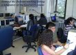
This semester the students had the opportunity to visit the facilities of the Puerto Rico Seismic Network (PRSN), located on our campus. Personnel of the PRSN explained to them the equipment and procedures they use to detect and study the seismic activity around the Caribbean region. First the students saw the main room to detect the earthquakes and even experienced the PRSN operation during a real event, which happened during our visit. Then the students went outside to see the seismic station located close to the building.
Once again, the students enjoyed the course very much as they indicated in the final evaluation. They represent a new group of professionals with a better understanding of the Earth System and with more conscience to preserve it.