Overview

The Puerto Rico Seismic Network (PRSN) evacuation maps and Map Tool are tsunami resources that support the development of a family or individual tsunami response plan. This module focuses on learning how to read these maps, particularly identifying key symbols and information.

Module Objectives

After completing this module, you will be able to:

    • Identify key symbols and other information on the PRSN evacuation maps and the Map Tool such as assembly points, evacuation zones, evacuation routes, and emergency sirens, without relying solely on the map legends.

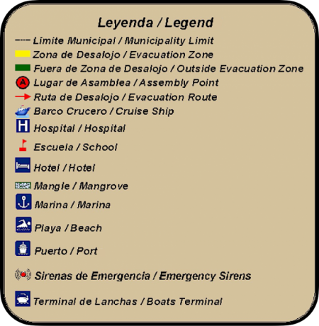
Evacuation Maps: Key Symbols and Information

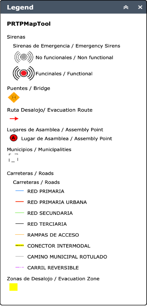
Tsunami evacuation maps contain a significant amount of information. However, in the context of a tsunami evacuation plan, there are a few key symbols necessary for developing this plan. 


Although the PRSN’s evacuation maps were originally intended for emergency personnel, they serve as a useful resource for any community member.  Remember, there is an evacuation map for each of the coastal municipalities in Puerto Rico, two inland municipalities (Yauco and Canóvanas), and the U.S. Virgin Islands (St. Croix, St. John, and St. Thomas). Note: The exact symbols included on the maps vary between municipalities. 

To facilitate the accessibility of the PRSN evacuation maps, the important information (such as the legend, assembly points, and contact information) is written in both English and Spanish.

Key Symbols

  • null

    Evacuation Zone

  • null

    Outside Evacuation Zone

  • null

    Assembly Point

  • null

    Evacuation Route

  • null

    Emergency Siren

  • null

    Hospital

  • null

    School

  • null

    Bridge

  • null

    Municipality Limit

Legend and Assembly Points

Each PRSN evacuation map contains a legend of the symbols on that map (displaying the key symbols and their meaning) as well as important information about locations and assembly points.  When reading the maps, the legends serve as a guide for you; as mentioned previously, the symbols included vary depending on which are relevant to a particular municipality.

A screenshot of the legend on the PRSN evacuation maps. It contains the symbols appearing on that particular map and their meaning.
A screenshot of a PRSN local evacuation map that shows a legend for the different assembly points on that map and their location

Emergency Management Contact Information

Only the evacuation maps for the municipalities of Puerto Rico contain the contact information for both the designated Municipal Emergency Management Office and the Puerto Rico State Agency for Emergency and Disaster Management.

This is a screenshot of a PRSN municipal map showing the contact information for emergency management office in San Juan
This is an example screenshot of the contact information for emergency management personnel on a PRSN evacuation map

Interactive Activity

Move your mouse over the map (for mobile devices, touch the map) to further explore the evacuation map symbols. If you identify the following symbols correctly, a small window/tooltip with the symbol’s name will pop up on the map.


Can you find…?

    • The 6 assembly points
    • The emergency siren near Parque Barbosa
    • The only hospital within the evacuation zone

Were you able to find all of the symbols without looking at the legend?

If not, don’t worry. There is more to learn!

Map Tool: Key Symbols and Information

Now that you have learned about the key symbols on the PRSN evacuation maps, it is now time to do the same with the PRSN Map Tool. The Map Tool contains variations of the same key symbols on the evacuation maps as well as other symbols that are only available on the Map Tool. These differences are partly because the two map types were developed at different times.


In the next module, you will learn how to use the interactive features of this tool.

Key Symbols

  • null

    Evacuation Zone

  • null

    Assembly Point

  • null

    Evacuation Route

  • null

    Functional

    Emergency Siren

  • null

    Non-Functional

    Emergency Siren

  • null

    Bridge

  • null

    Municipalities

Legend

The interactive Map Tool autogenerates a legend for each part of the map. This means that the legend varies depending on which part of the map you are reviewing. Remember that when reading the maps, the legends serve as a guide.

This is a screenshot of the Map Tool legend, which includes all of the symbols on the map and their meaning.

Why are non-functional emergency sirens on the map? This is because it is important to know where all the emergency sirens are located, even if they become non-functional from time to time.

Interactive Activity

Move your mouse over the map (for mobile devices, touch the map) to further explore the Map Tool symbols.  If you identify the following symbols correctly, a small window/tooltip with the symbol’s name will pop up on the map.


Can you find…?

    • The assembly point outside of the evacuation zone
    • The 4 emergency sirens (including the non-functional one)
    • The 4 bridges near Parque Barbosa

Knowledge Check

Test your knowledge about this topic by answering the following questions. You can review the correct responses by hovering your mouse over the boards with the word “Answer.”

1.  Which symbol appears on both of the following maps?
Zoomed in map tool image with red arrows
Zoomed in local map with red arrows

Answer

Evacuation routes

2.  What is indicated by the yellow shading on the following maps?
Zoomed in map tool image with a yellow shaded portion
Zoomed in local map with a yellow shaded portion

Answer

Evacuation zones

2.  Which symbol appears on both of the following maps?
Zoomed in map tool image with black A inside red circle
Zoomed in local map with a black A inside a red circle

Answer

Assembly points

Apply

See the notification box below to apply what you learned. Afterward, you can choose to continue with the next module or take a break and come back at another time.

Find your municipality’s evacuation map on the PRSN website! Review the key symbols that appear on the map and try identifying them without looking at the legend.