General View
The purpose of this module is to inform about past tsunami events in Puerto Rico and the Virgin Islands. Knowing how tsunamis affected is useful to prevent and mitigate possible future events.

Scroll down to begin this section.
2 3 Module 3The purpose of this module is to inform about past tsunami events in Puerto Rico and the Virgin Islands. Knowing how tsunamis affected is useful to prevent and mitigate possible future events.
After completing this module, you will be able to:
Now that we understand what tsunamis are and how they develop, let’s consider the sources that could affect Puerto Rico and Virgin Islands. Let’s begin by considering the tsunami sources in respect to its distance to Puerto Rico.
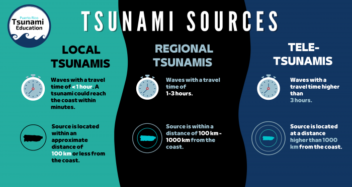
Of the three tsunami sources mentioned above, local tsunamis are the most dangerous. These could reach the coast within minutes, avoiding that authorities have enough time to issue relevant warnings. For this reason, attention is paid to natural tsunami signals such as: high magnitude earthquakes, abnormal changes of the water level or an offshore roar. If you hear, see or feel any of these signals, it is recommended to evacuate exposed zones and to find a high place in the shortest possible time.
Possible sources of local tsunami in Puerto Rico and Virgin Islands includes both earthquakes and submarine landslide. Puerto Rico and Virgin Islands are localized along convergence zone between North American Plate and the Caribbean Plate. To the North of the islands, the North American Plate subduct’s below the Caribbean Plate in the Puerto Rico Through zone.
To the North there is the subduction zone associated with the Puerto Rico Trench, to the West there is the extensional zone that forms the Mona Canyon, to the South there is the convergent “Muertos” Trough and to the East-southeast the Anegada Passage.
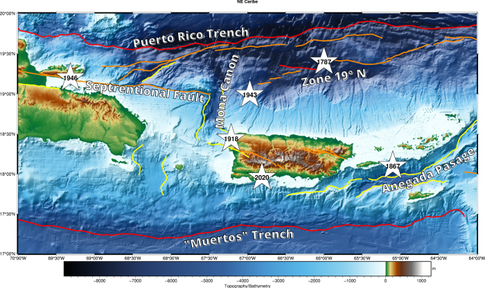
In 1867, an ~M 7.5 earthquake in the Anegada Passage generated a destructive tsunami that impacted Puerto Rico and the Virgin Islands. During the 2020 Southwestern Puerto Rico Seismic Sequence, the ~M 6.4 event on January 7th generated a minor tsunami recorded only on local sea level stations with an amplitude of ~0.04m, or about 1.5 inches. To the North, the last event that can be associated with the subduction occurred in 1946 in the neighboring Dominican Republic when an ~M 8.1 earthquake occurred. The last major destructive tsunami in Puerto Rico occurred in 1918, after an ~M 7.3 earthquake in the Mona Canyon.
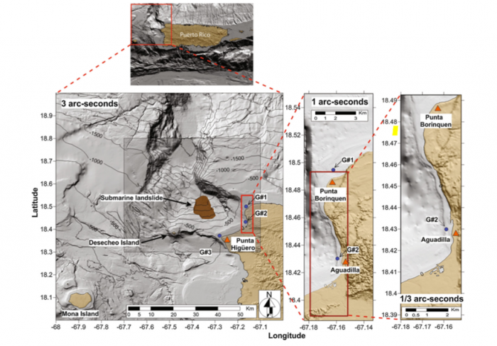
In addition to local earthquake sources, there is scientific evidence of submarine landslides to the North of Puerto Rico along the edge of the local sediment shelf. Such a landslide is capable of generating a tsunami. Researchers such as Dr. Alberto Lopez at the UPRM Department of Geology are currently studying this potential source to increase the preparedness of the region for such potential tsunamis.
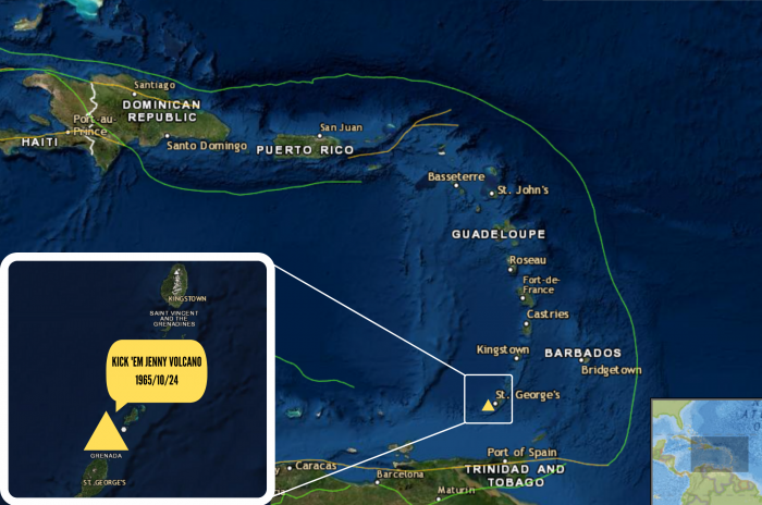
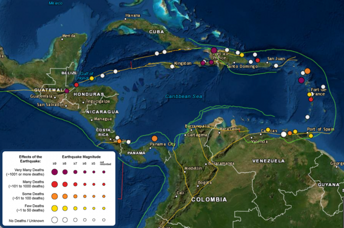
Regional sources for Puerto Rico and the Virgin Islands will be primarily earthquakes within the Caribbean Sea as well as potential volcanic sources from the submarine volcano Kick ‘Em Jenny. The earthquake sources in general are located around the border of the Caribbean Plate. On the eastern side of the Caribbean Plate, the Lesser Antilles are located along a subduction zone similar to Indonesia which may generate tsunamigenic events. Along the Southern margin of the Caribbean there is a zone of convergence where the Caribbean Plate and South American Plate are colliding. This creates a potential tsunami source along the coasts of Venezuela and Columbia. Central America denotes the western side of the Caribbean Plate where tsunamis can be generated along the coasts of Panama and Honduras. With these types of regional earthquakes, the shaking associated with the earthquake will often not be felt by people in Puerto Rico or the Virgin Islands, but a tsunami alert may be issued depending on the location and magnitude of the earthquake. We will go over these levels and what they mean in a future lecture.
On the regional scale, a unique source for the Puerto Rico and Virgin Islands region is the Kick ‘em Jenny submarine Volcano. This submarine volcano is monitored by the Seismic Research Center of the University of West Indies who ensure the local authorities in Puerto Rico and the Virgin Islands are aware of any significant changes in its activity and will inform if there is a large eruption capable of generating a tsunami.
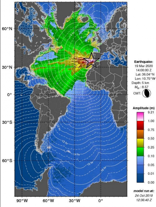
Teleseismic tsunamis are those tsunamis that are more than 1000 km away from our region. In the Caribbean the only recorded instance of this type of tsunami is the Lisbon Earthquake (1755). The tsunami took over 9 hours to travel to the Caribbean where there was a reported impact in Antigua. There is no report of this tsunami in Puerto Rico. One advantage that tele-tsunamis give the populace is time. After an earthquake, authorities and the public have hours to plan if/how evacuations are needed and ensure the safety of everyone. This is a distinct difference from local tsunamis where the populace has minutes to react.
The latest local tsunami was the case for the 1918 earthquake and tsunami that impacted Puerto Rico.
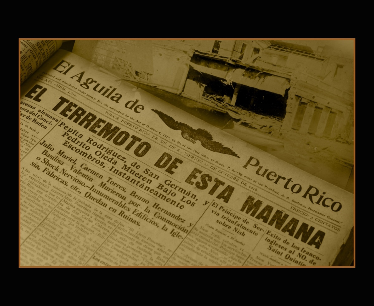
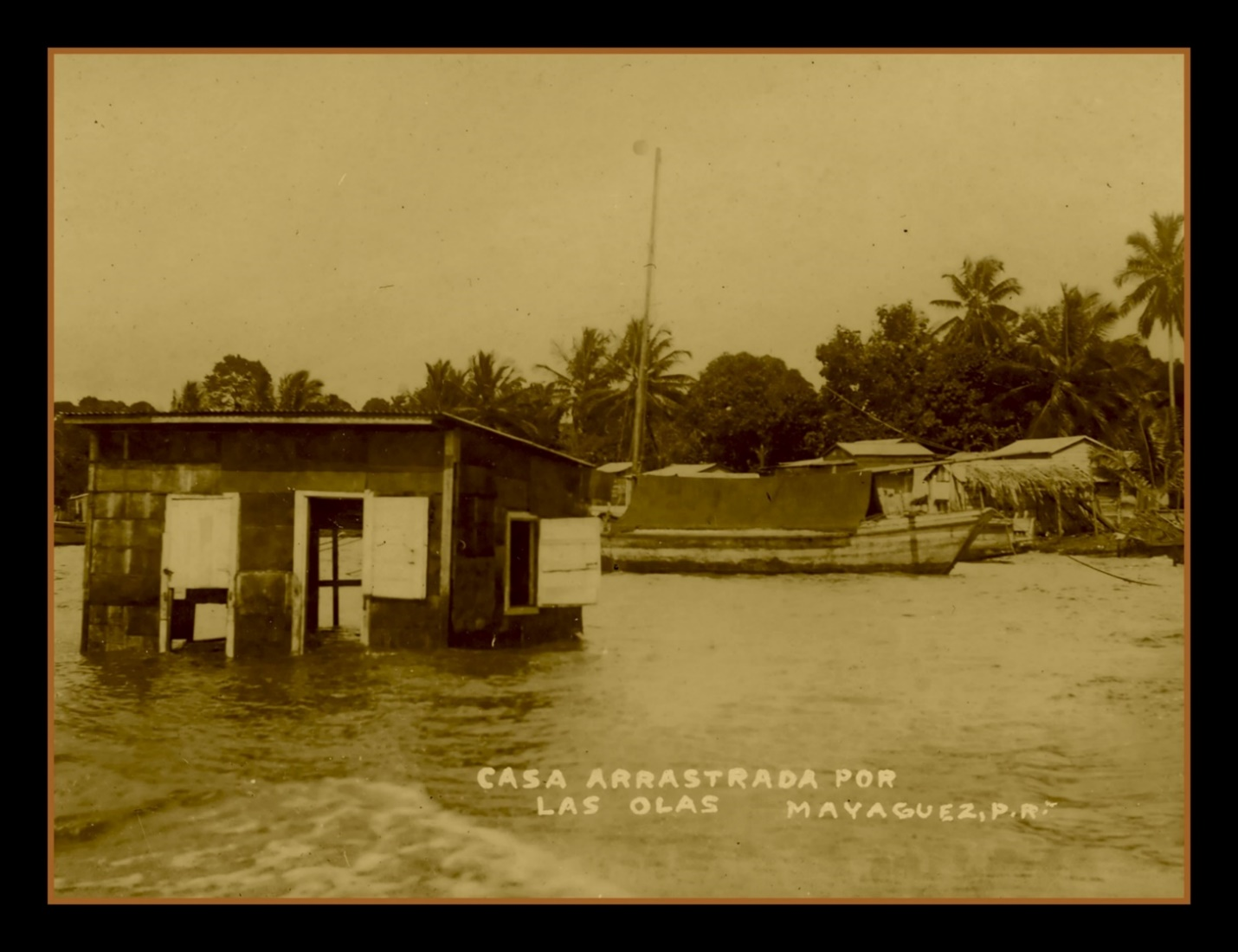
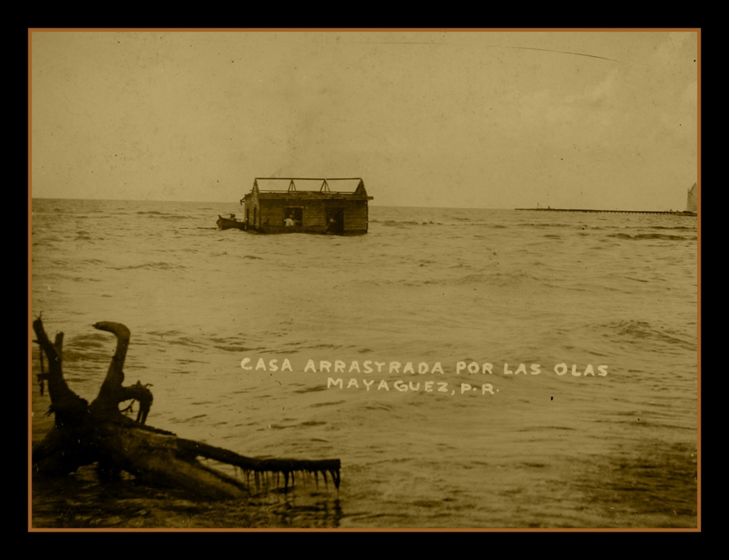
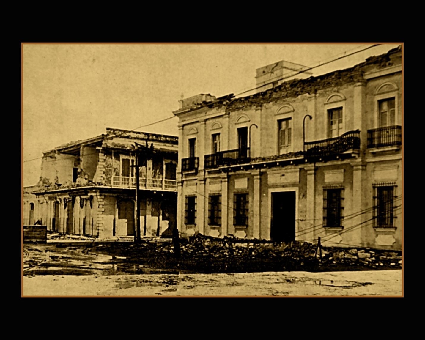
The 1918 earthquake and tsunami in Puerto Rico was the most recent destructive tsunami recorded in Puerto Rico. This tsunami is associated with an earthquake of approximate magnitude of 7.3 and occurred in the Mona Canyon. Minutes after the earthquake a tsunami impacted Punta Borinquen with a wave height of over 5 meters and then swept down the West Coast of Puerto Rico. The source of the tsunami is debated. The earthquake had an extensional source that would generate a vertical displacement and consequently a tsunami, but arguments have been made that the earthquake alone cannot account for the observed inundation. It has been suggested that to generate the observed tsunami, the earthquake must have triggered an offshore landslide. Currently scientists are searching for a viable landslide candidate in the Mona Canyon using high resolution bathymetry and underwater expeditions.
It is important to note that the ~7.3 M event did not have any recorded precursory earthquakes. In fact, the official report by Reid and Taber in 1919 noted that earthquakes in the region had not been felt for 6-7 months prior to the earthquake and tsunami. This highlights that tsunamis are an ever-present danger with a very short fuse; one must always be prepared to react to the danger. No matter the source of the tsunami, the impact along the coast was evident. In events such as the 1918 earthquake and tsunami it is difficult to separate damage from earthquake shaking and damage from the tsunami. It is worth mentioning that since 1918, the coasts have increased its population and the vegetation that could help as protection has been altered by man-made structures. A similar tsunami today would cause a much more devastating impact along the coast. Understanding past events like 1918 can help us prepare for future events.
Test your knowledge about this topic by answering the following questions. You can review the correct response by hovering your mouse over the boards with the word “Answer”.
(1) local tsunami (2) regional tsunami (3) tele-tsunami
Are tsunamis located at a distance bigger than 1000km.
Local Tsunamis
To help us understand what happened and to better prepare ourselves for future events.
See the notification box below to apply what you learned. Afterward, you can choose to continue with the next module or take a break and come back at another time.
Analyze. If authorities say that there is a possibility of a tele-tsunami and your house is close to the coast. What actions you should take? Why?