Overview
Having an established tsunami response plan is essential for responding appropriately to a tsunami event. This module focuses on developing a clear tsunami response plan that you can use as an individual or for your family.
 Module 5
5
Module 5
5
Scroll down to begin this section.
2 3 4Having an established tsunami response plan is essential for responding appropriately to a tsunami event. This module focuses on developing a clear tsunami response plan that you can use as an individual or for your family.
After completing this module, you will be able to:
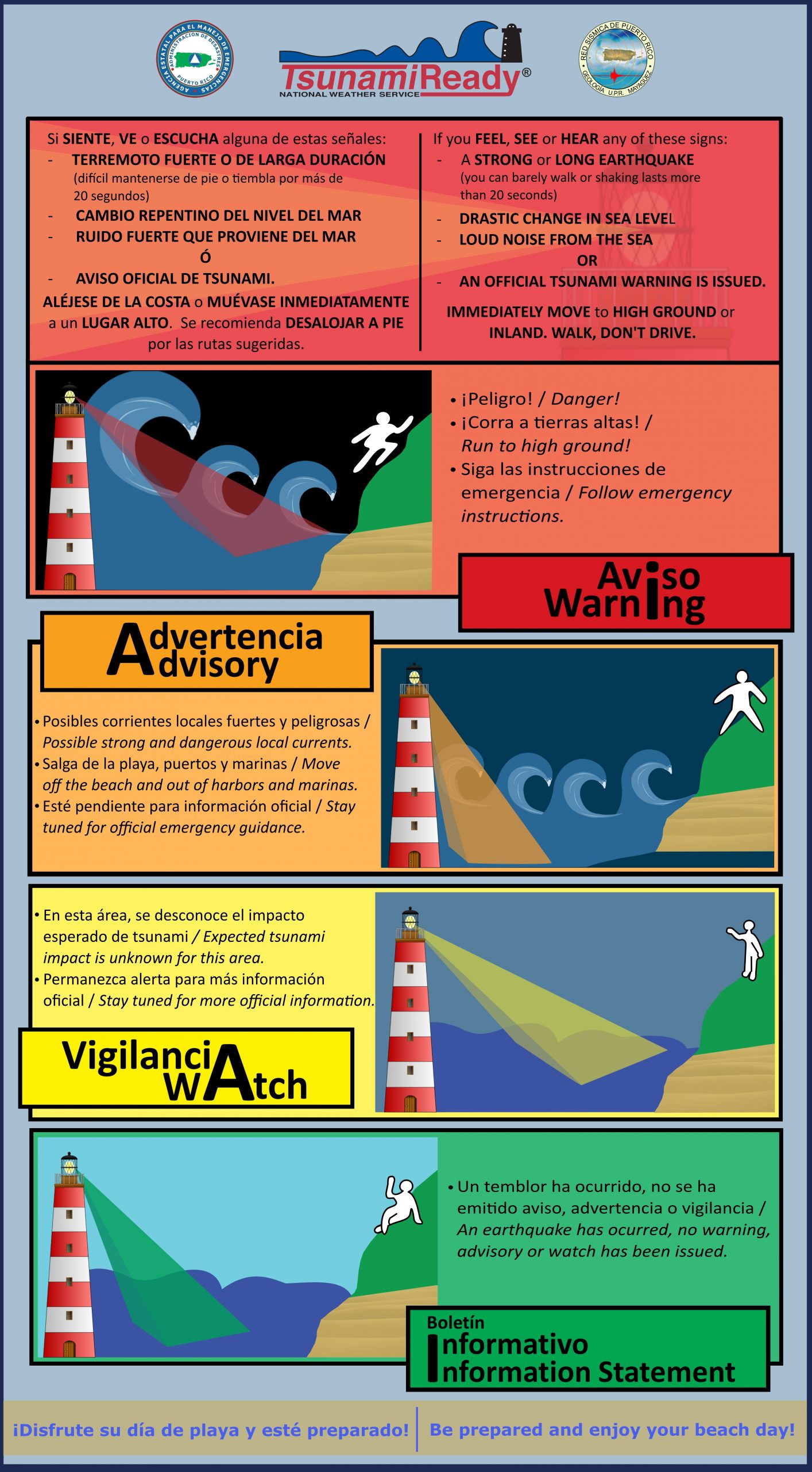
If you are located within a tsunami evacuation zone during a tsunami event and an official Tsunami Warning has been issued, you must evacuate. Although we did not cover the tsunami alert levels in this course, you may watch the following video created by the Puerto Rico Seismic Network (PRSN) to understand this topic better: Tsunami Warning Systems and Alert Levels.
See the images below to review the Tsunami Warning designated alert level and important information about tsunami evacuations.
We will now use the information we learned in Modules 1–3 to prepare for a worst-case scenario: a local tsunami. Remember that a local tsunami means that you have an hour or minutes to respond when a seismic event occurs very close to the coast of Puerto Rico. In the six steps below, we will work through how to prepare you and your family for a tsunami. Each step contains an example using the scenario in Module 3 when we calculated walking distance with the Map Tool.
Make sure the members of your household know where each other spend most of their time, as well as the addresses and phone numbers for those places. These locations might be home, work, school, and other family members’ houses. For this exercise, our example will only use “home,” but you should develop a response plan for each of these main locations.
Workplaces or schools may already have plans developed, and you should coordinate with the appropriate people to find out what the plans for those places are.
Example
The members of our family spend most of their time at home.
Address:
Urb. Mansión del Mar
MM-# Calle Sin Nombre
Toa Baja, Puerto Rico 00949
Phone Number:
(787) ###-####
Use the map resources from PRSN to determine whether any of these locations are in an evacuation zone. It is important to realize that you will not necessarily be at home during a tsunami.
Example
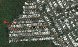
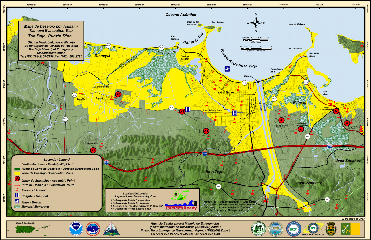
Yes, the entire Mansión del Mar community is within the evacuation zone in Toa Baja, Puerto Rico.
Make sure you know where the nearest assembly point is ahead of time, so you do not have to figure it out during an emergency. It is also important to know at which assembly points your family members might be if you are separated during a tsunami emergency (for example, if one member of your family is at work and another is at home).
Example
The nearest assembly point is located southwest of the house.
Address:
Coliseo Antonio R. Barceló
Vía Arco Iris
Sabana Seca, Toa Baja, Puerto Rico 00949
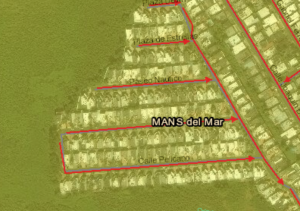
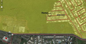
The evacuation routes have been designed to get you out of the evacuation zone efficiently. When identifying your evacuation route, make sure not to cross any bridges as they could be affected by an initial event, such as an earthquake.
Example
In the image below, we can see that the evacuation route takes us west from our house on Calle Pelicano to Via Azures, right onto Avenida Sabana Seca, and left onto Vía Arco Iris.
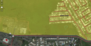
Remember, you will have to evacuate on foot to keep the roads clear for emergency vehicles. If you do not remember how to calculate distance using the Map Tool, return to Module 3.
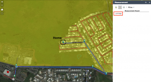
Example
As shown in the image below, we used the distance measurement tool in the interactive Map Tool to find that we would have to travel about 1.07 miles from our house to the assembly point along the evacuation route. Then, we calculated that it would take about 25 minutes to walk this distance.
You may also want to circle or highlight your starting point, the evacuation route you would take, and the nearest assembly point for easy reference during an emergency. You can use the PRSN evacuation maps or personalize your own with the interactive Map Tool. If you use the interactive Map Tool, make sure you record the important information (such as emergency management services contacts) that is only included on the PRSN evacuation maps.
To review what items must be included in your emergency backpack, follow this link to the Puerto Rico State Agency for Emergency and Disaster Management website.
Currently, this website is only available in Spanish.
Example
We found the Toa Baja evacuation map on the PRSN website and printed copies for each of our family members’ emergency backpacks.
The Puerto Rico State Agency for Emergency and Disaster Management works closely with PRSN to educate the community about tsunami preparedness. On their website, you will find resources and information that will help you to prepare for various disasters, including tsunamis. For example, the Family Emergency Plan helps you develop an emergency plan, which goes hand in hand with the tsunami response plan above. To answer the form’s questions, you will need to know whether your house (or other location) is within a flood zone.
Currently, this website is only available in Spanish.
Remember to use either the PRSN’s evacuation maps or the Map Tool to determine whether your community or workplace needs to evacuate during a tsunami event.
Test your knowledge about this topic by answering the following questions. You can review the correct responses by hovering your mouse over the boards with the word “Answer.”
You may not all be at home during a tsunami event.
A printed copy of the evacuation map (or Map Tool) that highlights the evacuation route from your home.
See the notification box below to apply what you learned. Since this is the final module, you can choose to review the Resources page or continue with the Quiz to evaluate what you learned throughout this course.
Follow the steps in the example above using your personal situation to answer the questions. For this exercise to be most effective, complete it with the members of your household. This will ensure that you can use the PRSN map resources effectively to prepare you and your family for a tsunami.