Overview

After learning what evacuation maps are and how to use MapTool (both available in the Puerto Rico Seismic Network), this module will focus on how to use and apply the data layer in the Pedestrian Analyst within the MapTool. Additionally, the previously presented the equation of time and distance will be put on practice. The purpose of this module is to determine the approximate time it takes to move out of the evacuation zone.

During this module you will need access to the PRSN maps.

Module Objectives

Before this module you should:

    • Know how to download and interpret evacuation maps
    • Recognize an evacuation route
    • Understand MapTool
    • Know how to use the time and distance equation

After this module you shall:

    • Use and interpret the pedestrians
    • Establish possible evacuation routes using MapTool
    • Recognize and put on practice the Pedestrian Analyst layer
    • Calculate the approximate time it takes to get out of an evacuation zone using the equation of time and distance

Past modules established where to access the evacuation maps of the Seismic Network as preparation and mitigation, how to work with MapTool and the time and distance equation was provided. This module will focus on utilizing said maps to make a pedestrian analysis that gives an estimate of time of how long it takes to evacuate a flood or evacuation zone.

Review

Evacuation maps are detailed and specific maps to aid with the evacuation before and after a tsunami situation. These contain valuable information about vulnerable areas for flood and inundation. The maps vary for municipality and are accessible in the Puerto Rico Seismic Network webpage, under the tab of Tsunami.

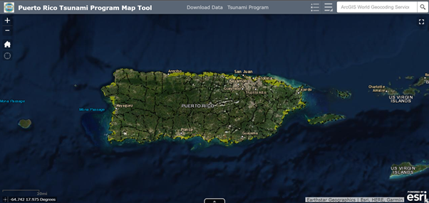
The “Map Tool” is an interactive tool based on Geographic Information System (GIS) that its useful to visualize different information layers including evacuation maps.

Figure 3: Map Tool feature of Puerto Rico Tsunami Program
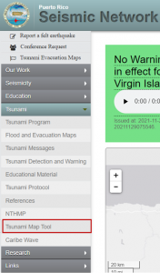
Figure 2: Tsunami MapTool Tab

To estimate the distance it takes between a starting location and a location out of the evacuation zone one should use the following equation:

Figure 4: Time and distance equation

To review the tsunami maps, please access the Maps Course

What is a Pedestrian Evacuation Analysis?

A pedestrian analysis refers to a information layer, developed by the tsunamis program utilizing Geographic Information Systems (GIS). This layer was created using a tool called Pedestrian Evacuation Analyst by the United States Geological Service (USGS). The layer helps calculate the estimate time it takes to get out of an evacuation zone in case of a flood due to tsunami. Said layer can be applied to Geographic Information Systems such as MapTool or ArcGIS (TsunamiReady).

With this layer one can get the approximate time it takes to get out of the evacuation zone using the time and distance equation and the average speed a person walks. To habilitate the pedestrian analyst feature on MapTool: Layer List > PRTPMapTool > Pedestrian Analyst.

Within the layer there is three options for the velocity of a pedestrian:

  1. Slow walk: 2.46 mph
  2. Average walk: 2.7 mph
  3. Fast walk: 3.4 mph

It is important to take in mind that this is an evacuation time estimation, it is not perfect because it does not takes into consideration: health issues, obstacles, closed ways, and others.

What happens when you activate the Pedestrian Analyst layer?

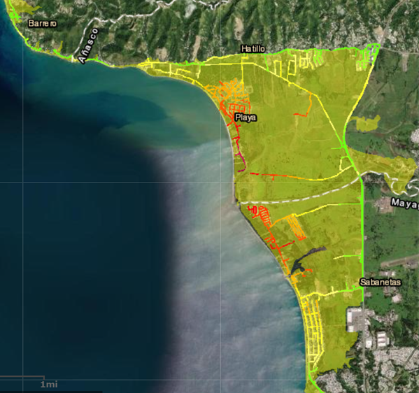
When you activate the layer, information represented by colored lines will appear on the map. These lines go from green to red that indicate the proximity to a high elevation area. Green meaning that the area is within or close by to high ground and red meaning it is more apart from an area of high ground.

Figure 5: Representation of the Pedestrian Analyst layer

Not all municipalities have a Pedestrian Evacuation Analysis layer. This layer is in continuous development every year as the tsunami team adds new municipalities to the MapTool.

Steps to make a Pedestrian Analysis

Step 1: Determine a starting point.

After downloading the municipality’s evacuation map it is recommended to determine a starting point, preferably a house.

Step 2: Determine a location out of the evacuation zone.

After selecting the first starting point, determine a point out of the evacuation zone.

Step 3: Determine the distance between points.

To determine the distance between locations one can use the MapTool feature.

Step 4: Habilitate the Pedestrian Analyst.

The pedestrian analyst is the layer of MapTool that allows you to calculate an estimate of walking time.  One can choose a walking speed under the tab of layers.

Knowledge Check

Test your knowledge about this topic by answering the following questions. You can review the correct responses by hovering your mouse over the boards with the word “Answer”.

1. What is a pedestrian analysis?

Answer

A layer of information created by the USGS to calculate an estimate of time it takes to get out of an evacuation zone

2. Where is the Pedestrian Analyst layer available?

Answer

Map Tool

3. What does the red lines in the Pedestrian Analyst mean?

Answer

the area is apart from a high ground zone

Apply

See the notification box below to apply what you learned.  Since this is the final module, you can choose to review the Resources page or continue with the Quiz to evaluate what you learned throughout this course.

Follow the steps in the example above. Use the location of a place within the evacuation zone and, using the time and distance equation, determine the estimate time it takes to get out of the zone.